| Fort Peck 1966 shows second powerhosue started in 1956. Graphic restoration by Al Barrus. |
 |
A dusty automobile carrying four passengers bounced over graded section-line roads outside of Glasgow, Montana, on 28 October 1932. The auto passed through fields of wheat and into unplowed grass. The machine stopped - overlooking the flood plain of the Missouri. Two of the men in the car lived in Glasgow. Sam Rugg represented the Chamber of Commerce, and Leo B. Coleman servedas town mayor. The others were Engineer officers, Lieutenant Colonel Richard C. Moore and Captain Theodore Wyman, Jr. Moore and Wyman expla ined the purpose of their visit to Valley County. They told Rugg and Coleman that the Corps of Engineers planned to build a huge earthfill dam from where they stood across the Missouri to the opposite shore.
Mayor Coleman looked at Moore, Wyman, and Rugg and then back to Moore. "My God, man!" Coleman said in utter astonishment, "It would cost a million dollars to build a dam across there."
By October 1932, the Depression had hit Montana hard. Families in Glasgow and surrounding Valley County were already desperate. After the drought of 1929, lucky farmers got 4 bushels of wheat to the acre. The unlucky ones went hungry. Nineteen hundred and thirty was even worse. By July of 1931, 80 percent of Valley County's farms were mortgaged and the others carried chattel loans.
 |
| Fort Peck first powerhosue and switchyard |
The idea for a dam at Fort Peck originated in the years after the Civil War. In 1866, 3 miles upstream at Peck 's Point, the steamer Tacony hung up on a sandbar. Her crew made the best of a bad thing, built the first of four log forts in the area, and started to trade with the local tribes. The next year the firm of Durfee and Peck took over the establishment, named it Fort Peck, and began what became a booming business. In 1873, the trading post added a function - the Milk River Indian Agency. On 23 March 1877, an ice gorge developed a mile downriver.
The river backed up and inundated the fort while ice tore away the stockade. Colonel Campbell Kennedy Peck, owner of the fort and friend of President Chester A. Arthur, supposedly went to Washington, D.C., in 1879 and pleaded for a dam to serve navigation and irrigate reservation lands. Fifty years later, local interests and politicians still wanted a dam at Fort Peck. Nebraska's former Governor Arthur I. Weaver served as president of the Missouri River Navigation Association, which was formed in 1925 to campaign for increased navigation on the Missouri.
Montana's powerful Senator Burton K. Wheeler also wanted the dam for his constituents. The Glasgow Chamber of Commerce hoped the dam would boost the local economy and so told the Engineers at a meeting in April 1933. Fort Peck was the first product of a comprehensive analysis of the needs and resources of an entire river basin. Water resource development by the Federal Government had been moving in this direction for some time. Irrigation had become a legitimate Federal activity with approval of the Reclamation Act of 1902. Flood control had developed into a Corps mission after passage of the 1917 Flood Control Act. Eleven years later, Congress specified inclusion of the Missouri in any plan for control of floods on the Mississippi. Then, in the 1930's, came the Corps' "308" reports with their thorough basin-by-basin assessments of the Nation's waterways.
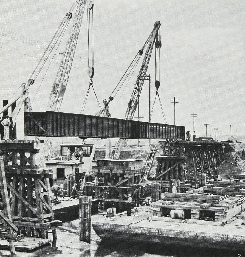 |
| Derrick boats lifting swing bridge |
 |
| Commencement of rock bumping into toe |
The "308's" took their name from a six-page House of Representatives publication. House Document 308 contained a joint report by the Chief of Engineers, Major General Harry Taylor, and Executive Secretary O. C. Merrill of the Federal Power Commission on the contents and cost of a comprehensive survey of the Nation's waterways. The report, required by Congress in the River and Harbor Act of 1925, paid special attention to the future development of hydroelectricity. However, the brief proposal also encompassed improvement for navigation and the control of floods, as well as the need for irrigation.
This congressional interest became law in the River and Harbor Act of 1927. This act required detailed studies of all principal river systems except the Colorado, which was already under investigation by the Bureau of Reclamation. In the following decade, the Corps completed 191 such reports, inaugurating a new period in water resource development. From that time, planning moved from "the single-purpose, single-project" approach to multiple-purpose basin-wide development intended to maximize the beneficial uses of the Nation's waterways.
The report for the Missouri, written by Captain Wyman in his capacity as District Engineer in Kansas City, Missouri, provided a detailed, comprehensive examination of the entire river system. Almost 1,200 pages long, Wyman's report reviewed previous efforts to improve navigation and control floods and described in detail the region and its waterways. In addition, he assessed various options for the continuation of work on the Missouri. All told, he believed he had arrived at "the best plan for the maximum utilization of the water resources ... of the Missouri River," for navigation, flood control, irrigation, and the production of power.
Wyman's "308" proposed projects for all four of these purposes. His recommendation for flood control focused on a system of levees for the Kansas City vicinity, where the largest problems occurred. The plan also included several Montana irrigation projects and identified 16 upper river sites for generation of hydroelectricity. For the benefit of navigation, he advocated continued improvement of the river from Kansas City to its mouth on the basis of the existing project and application of the same project to the reach between Kansas City and Sioux City, Iowa.
Low-water flows in both reaches would be supplemented by waters released from headwaters storage, most notably behind a dam at Fort Peck. Wyman wanted "construction of the Fort Peck navigation reservoir to fulfill present navigation requirements [and] as the first step in the ultimate development of the combination power and navigation scheme." Through the summer of 1933, crews of engineers from the Kansas City District swarmed over the dam site, though the project had not been formally authorized. The site was chosen for its ample water supply, favorable foundation conditions and topography, freedom from silting, and economy of water storage. In fact, a dam at Fort Peck could store enough water for a 9-foot-deep navigation channel all the way from Yankton, South Dakota, to the mouth. In July the surveyors ran geological tests to measure the foundation site of the proposed dam.
 |
| Pumpboat No. 3701, which weighed approximately 182 tons, being towed by 14 large crawler-type tractors |
Other crews surveyed the route for a rail spur from the Great Northern's main line at Wiota, Montana. The preliminaries were underway. On 30 September 1933, with sufficient justification
for the project in hand, the Chief of Engineers, Major General Lytle Brown, recommended the work. With $84 million available under the National Industrial Recovery Act and channeled to the Corps of Engineers through the Public Works Administration, President Franklin D. Roosevelt approved construction 2 weeks later. Within a week of
Roosevelt's decision , Wyman opened a sub-office of the Kansas City District in Glasgow.
It is important to remember that while Fort Peck represented an essential part of the Missouri River development plan, it also fit the needs of a Government anxious to revive the national economy. Fort Peck Dam provided work, stimulated industrial production, and strengthened the economy. It demanded the manufacture of great fleets of earth-moving equipment, rolling stock, electrical equipment, and other machinery. The dam directly employed as many as 10,546 men at one time at the site and thousands more across the country. If the project ultimately aided navigation, so much the better.
Events moved quickly and, on 27 October 1933, the first legal step toward the creation of the Omaha District occurred. General Orders, NO. 9 established the Missouri River Division of the Corps of Engineers. Moore became Division Engineer charged with planning and designing Fort Peck Dam. Wyman continued as Kansas City District Engineer and Major Thomas B. Larkin went to Glasgow as Area Engineer in November to take charge of the office there. By 1934, Larkin employed 7,236 people on the project. In 1935, the workers totaled 7,110, and in 1936 their numbers reached a record 10,546. The Fort Peck Dam served as a training ground for tens of thousands, civilian and military. The experience gained on the project created the nucleus of the Omaha District's force that later constructed the great main stem dams on the Missouri.
 |
| Twenty-eight-inch pipeline dredge Jefferson working downstream. The dredge Jefferson was built at Fort Peck |
The best thing about the dam, however, was that a common laborer could work 34 hours a week at 50 cents an hour. At a time when a man could buy a beer for a nickel, those were good wages Larkin 's responsibilities grew on 1 December 1933 when the Fort Peck District of the Missouri River Division became formally activated with him as the District Engineer. Larkin staffed his office with personnel from other Districts, such as George Feil and Chalmers B. "Bart" Stokes of the Kansas City District, who later joined the Omaha District. At that time, the Army Air Corps made aerial surveys for land acquisition and Department of Agriculture officials made land appraisals.
Considerable acrimony and litigation accompanied acquisition of real estate for the large projects in the Missouri River basin. This pattern began with Fort Peck Dam. The problems there had two underlying causes. Homesteaders put considerable effort into making the raw land into farms or ranches and did not wish to give up what they built. Moreover, the Depression drove land prices down. Federal law and real estate practice demanded that land be purchased at the current fair market value and, in 1933 and 1934, practically no market existed.
 |
| Hydraulic fill showing discharge |
Fort Peck Dam differed from subsequent structures on the Missouri River in two important ways. The dam originally did not include facilities for generation of hydroelectricity and contained hydraulically placed earthfill . Therefore, the project, as Colonel Larkin wrote, "naturally divides itself into three major construction features; the dam itself, the diversion tunnels, and the spillway." Before these features could be built, the foundation had to be prepared, equipment to pump and place the fill had to be built, utilities and transportation had to be arranged, and a town to house the workers had to be constructed.
During four miserably cold months in the winter of 1933 and 1934, hired laborers laid a 12-mile railroad spur over which materials from the Great Northern's main line at Wiota moved to the dam site. Eventually, 60 miles of track laced the project. The Minnesota Bridge Company carried the rails across the Milk River and the Massman Construction Company of Kansas City placed a single-lane auto and rail bridge across the Missouri over the dam site. From a quarry 70 miles away, gravel came over the bridge in 100-car trains. The trains ran onto a trestle above the dam toe and dumped the gravel in place. From Harlem, Montana, 130 miles away, railroads brought 1 million cubic yards of rock to protect the upstream face of the dam from ice and wave erosion. An engine house, built for maintenance of the rolling stock and supplied with soft water from the new Fort Peck City laundry, had four 450-barrel capacity diesel and fuel oil tanks.
 |
| Spillway discharging from core pool |
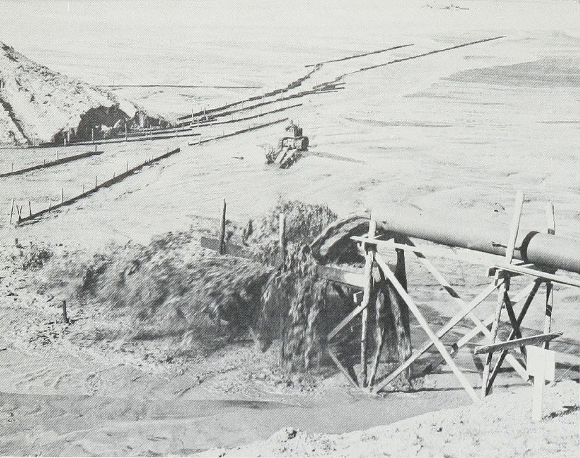
The Montana Power Company's generating facility at Rainbow Falls, 288 miles above the site, supplied electricity through a 154,000-volt line. Zeibarth and Walker, Inc. of Los Angeles, Allis-Chalmers, Westinghouse, and the A. S. Schulman Electrical Company of Chicago placed transformers, switch yards, and the hundreds of necessary pieces of equipment. The embankment got underway with construction of another fleet of Corps vessels, including four dredges. Fort Peck was a long way from the nearest shipyard. Government equipment and hired labor erected a boatyard where they built and launched the dredges and their attendant equipment. With a dredge season of only 7 months, the dredges used their 7-foot cutter-heads to dig their own ice harbor.
In January of 1934, 17 men carried their own hand tools, marched to the river's edge, and began Montana's most productive shipyard. The workers started the first hull in January 1934 and launched it 5 months later. Six four by 10-foot barges, all of them six feet deep, and four wooden-hulled dredges came down the ways. The dredges, electrically operated with current equivalent to 12,000 horsepower, could lower their cutter-heads 50 feet into the water. Each cutter-head connected to a pair of pumps on a booster barge and to a land-side booster mounted on rails and equipped with a single 2,500-horsepower pump. The dredges pumped an 85-percent water and 15-percent clay mixture into the cavity formed by the embankment.
 |
| The downstream slope of the dam and core pool. Shows tunnel inlets, outlets, and completed gate structure of spillway. |
Eventually, the dredges pumped the slurry to a height of 240 feet, four times higher than ever done before. Five miles of 28-inch-wide pipe carried the slurry from the dredges to the land-side boosters across some of the 20-foot-square pontoons, 384 of which were built in the boatyard. From the boosters the slurry was pumped into core pools behind the embankment.
There the clay precipitated out of the water to become the dam's impervious core. The carrying water then flowed through a complex metal spillway back into the river. The first dredge was launched in June 1934 into 3 feet of water. Three more followed at the end of October, and the booster barges were launched a week later. In the meantime the first dredge finished the 4,000 by 200-foot winter harbor which provided security in the off-season. In addition to the dredges, barges, and pontoons, the Engineers built another 263 vessels at Fort Peck and a total of 655 craft came down the shipyard's ways.
In addition to building a fleet, Moore and Larkin planned and built a city to house the 4,000 people who erected the dam. Although most of the buildings were temporary and the project schedule was extremely tight, the Corps did not overlook aesthetic considerations. Landscape architects coordinated the layout with the topography. Also, use of a variety of designs avoided the monotonous appearance so common to construction camps.
 |
| Mucking machine placing excavated material on loading gantry. |
Private firms under contract to the Corps carried out construction. Three Minneapolis, Minnesota, businesses did much of the work. Madsen Construction Company built laborers' barracks, foremen's dormitories, and managers' residences. Johnson, Drake, and Piper and the C. F. Halen Company both constructed some residences and a wide range of community facilities. A fourth firm , Wm. McDonald Construction Company of St. Louis, Missouri, built most of the town's garages. The administration building and 12 homes for higher officials were of permanent construction for use during the dam's ongoing operation. The laboratory and town hall were built for immediate use as were 261 temporary homes of 7 sizes and 36 floor plans. Two bunkhouse areas for men who lived without families were built away from the center of town.
Nine blocks of bunkhouses, with two bathhouses and a mess-hall for each block, served the laborers. Each bunkhouse accommodated 30 men. Three blocks of eight foremen's dormitories each went up. Each foremen's dormitory had indoor plumbing and housed 15 men in single rooms. There was a mess-hall for each block of the dormitories and two 26-car garages for the foremen's use.
Single women lived in two dormitories and ate in a dining hall built especially for them. In addition to the housing facilities, the town boasted a 12-store business block and a 40-bed
hospital, as well as a school, a theater, and a recreation building. The quaint wooden theater, built to resemble a Swiss chalet, seated 1,200. In its heyday, the theater featured the latest Hollywood extravaganzas around the clock.
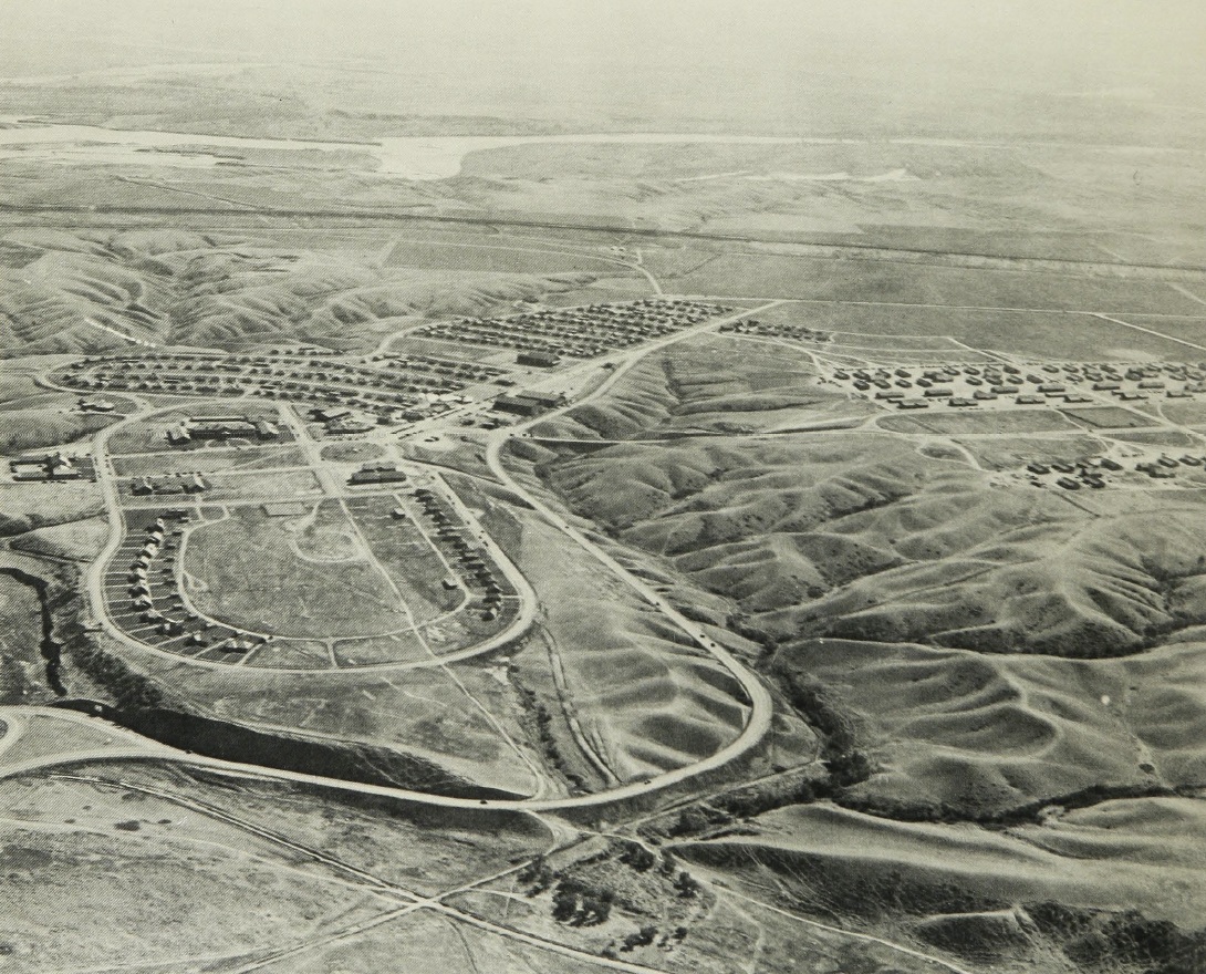 |
| Photo dated 11 September 1936 showing town of Fort Peck with permanent residential district in foreground, business and temporary residential area in background, and barracks area at right. |
The town's Recreation Association sponsored many events, athletic leagues in the various sports seasons, and tours through Montana's countryside. The 90-room Fort Peck Hotel served travelers with business at the dam. The laundry, a garage, a commissary warehouse, a cold storage plant, and a 5,000-ton-capacity ice-house rose to serve the city. Morrison-Knudsen Corporation of Spokane, Washington, paved the streets, laid down sidewalks, and installed complete water, sewage filtration, and street lighting facilities. Cheap natural gas for heating
came to Fort Peck through an 8-inch pipeline from Glasgow which, in turn, connected to the nearby gas fields of Saco, Montana.
The inability of some workers to find or afford housing in the town led to the emergence of a seamier side of construction camp life. A failure of coordination between Federal and State officials created a lack of sufficient residences for married men and their families in the town of Fort Peck. The Corps assumed that most of the workers would be single and did not design a family town: the original plan envisioned only 300 family residences. Montana law, on the other hand, gave hiring preference to married men with dependents. Within months, about 75 percent of the work force consisted of family men.
 |
| Applying primer coat to steel lining |
The lack of space in town and the 50-cent wage forced some of these people to make desperate choices. Many men spent $40 to $75 on lumber and banged together 8 by 16-foot shacks. Soon
shantytowns named Wheeler, Delano Heights, Square Deal, Park Grove, and Wilson sprang up. There, workers and their families did without electricity and took their water from shallow, often contaminated, wells at a penny a gallon.
The combination of circumstances which created planned communities for single workers and compelled families to fend for themselves gave an unusual twist to a standard feature of the frontier west. Boom towns - known as "hell on wheels" when they developed at the end of track during railroad construction - marked every stage of western development. Traditionally home to single men and the saloons, casinos, and brothels that followed them, these towns sprang up in the wake of mines and construction projects as well as railroads. With single workers in a well-ordered stable community and families in boom towns, the Fort Peck project turned this standard phenomenon of the frontier on its head. When Engineer Captain Ewart G. Plank, who served as town manager, boasted that the town "stands in striking contrast to construction camps of even the recent past," he conveniently ignored the nearby shantytowns.
At the dam itself, dredging for the embankment commenced after the ice went out in 1935 and construction crews began the four diversion and intake tunnels. The workers drove these through the shale for distances of between 5,386 and 7,262 feet. Originally designed to have 26-foot inside diameters and to sit 125 feet apart, the tunnels demanded innovative digging methods. Gangs of 12 men at each tunnel face tried to cut into the shale with rock saws. Then, Sullivan Machinery Company, a maker of coal saws, supplied saws to chew 9 feet into the shale and pivot about an axis to make a 15-foot diameter circular cut. When sawn, the material was blasted out of the tunnel face, mulched in 6-yard dump cars on rails, and moved out of the work area
while the digging progressed.
A problem developed in the outlet pit at the downstream ends of the tunnels. During the pit's excavation, bentonite fault seams in the bedrock caused several extensive landslides. Bentonite, a clay-like volcanic ash, retained several times its own volume of water. The bentonite seams acted as a lubricant and allowed other subsurface materials to slide on their fracture planes. As the Engineers later learned, many Missouri basin dam-sites contained these seams of bentonite. When loosened by the excavation work, the shale rode down these seams and
caused the landslides.
 |
| Pouring concrete into lining of the main control shafts. |
Bedrock itself also presented a problem. The soft and slippery material, known locally as Bearpaw shale, extended downward in a layer about 1,000 feet thick. A cubic foot of the blue-gray substance weighed close to 140 pounds. When exposed to the dry Montana air, the shale lost its moisture and crumbled. If whetted again, the pieces turned to mud. To counteract these tendencies, underground tunnel excavators maintained a subsurface humidity of at least 90 percent with atomizing sprays spaced at 200-foot intervals. In addition they immediately
sealed all final rock surfaces with asphalt paint or Gunite spray. Final concrete facing was then placed as quickly as possible.
Originally, the tunnels were to be lined with 21 inches of concrete, 6 inches of grout, 9 inches of reinforced concrete, and an inch of steel. The Corps became dissatisfied with the contractor's progress on these dimensions, took over the job on 15 January 1936, and continued with its own machinery and hired labor. The tunnel dimensions were reduced to a 24.67-foot diameter. All bolted joints were welded, the tubes given a 36-inch concrete lining, and, in all except one tunnel, the steel liners omitted. An additional 24-inch lining brought the complete sections of the tunnels up to the new specifications.
Montana winters can be extremely cold. During the raising of the dam, temperatures sometimes plunged to 66 degrees below zero, and diesel and fuel oil were handled by the frozen cake rather than poured. Nevertheless, the work in the tunnels went on. Because of weather conditions, 200,000 cubic yards of sand and gravel for concrete had to be washed and stored in the summer and then warmed during the winter. Steam heat thawed the material as it passed to the mixing sites on conveyor belts.
Time was of the essence in this work, and concrete was poured at temperatures as low as 17 degrees below zero. Steam-heated wood and canvas shelters protected the finished work. Professional miners did much of the work in the tunnels. Four thousand men working in shifts around the clock completed the tunnels on 24 June 1937. The tunneling proved to be a tough, slippery job. Over 5 million cubic yards of material came out of the tubes, while 57,000 tons of steel and 600,000 yards of concrete went into the digging and shoring.
Each tunnel had an intake tower and each tunnel alone could carry the normal flow of the Missouri River. To protect the dam from "piping," water trying to take a natural course through a seepage-way, French drains were installed between the abutments and embankment. Composed of porous filler material, the drains permitted water to pass through the dam in a controlled manner. The inevitable passage of water through an earth-fill dam can be predicted, controlled, and allowed. At the Fort Peck Dam, water could not be permitted to percolate through the immediate foundation strata of the embankment. The workers drove a steel cutoff wall or diaphragm into the foundation. They placed slabs of sheet steel which were linked together into the foundation to form a barrier against the water. The cutoff wall reached a record depth of 163 feet into the area under the impervious core. When completed, the cutoff wall measured over 10,000 feet long and contained 17,000 tons of steel.
 |
| To right, steel cutoff wall |
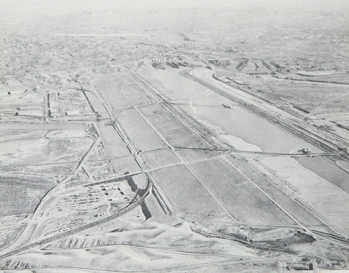
No less massive, the spillway stretched out for 1 mile, symmetrically tapering from 800 to 125 feet in width. It rested on a 5.23-percent grade to allow a flow with a velocity of 65 miles an hour. A total of 14 million cubic yards of material was excavated for the spillway, and an 18-mile drainage system of vitrified tile was laid where the concrete slabs join. Over 450
concrete piles, 30 to 40 feet long, supported the 12-foot-thick foundation slab for the spillway gates.
A bridge over the structure held sixteen 10-ton Stoney gates that release water from the spillway. These gates consisted of great vertical slabs of steel raised by cables and powerful electric motors and were installed nowhere else on the Missouri River. The other five main stem dams were equipped with Tainter gates, great steel arcs on pivots that lift more easily and seat better than Stoney gates. The spillway structure containing the Stoney gates was built of 54,000 cubic yards of concrete and 26,500 tons of steel.
Two weeks after completion of the dam, on the morning of 22 September 1938, the daily inspection of the embankment revealed a problem. The core pool level appeared awry, and survey crews went immediately to learn if earth movement had occurred in the dam. The pool had not moved, but the pipeline on the upstream shell ran lower than it should have. The railroad tracks had not moved. Men were allowed to continue working in the area. At 1 :15 p.m., the District Engineer was being driven to the worrisome spot when the dam began to move. His driver slammed the sedan into reverse as the core pool over-topped the dam's embankment. The pool then began to settle and the crest receded. Almost immediately, part of the main mass of the upstream shell swung into the reservoir as if hinged on the abutment.
 |
| Entire spillway gate structure with channel in background, 16 verticle lift gates, and the highway and service bridges |
For 10 agonizing minutes, tracks, trains, boats, pipeline, and 34 men rode the shifting, 1,700-foot mass. When it came to rest, the equipment was submerged and eight men were dead, buried in the slide. Over 5,200,000 cubic yards of material came loose from the dam. Five percent of it had been destroyed. As soon as the rescue operations ended, the Engineers began a complex series of tests to determine the cause of the failure. These tests included mechanical analysis, moisture content, core filling, and material consolidation tests. Core samples were also taken, including some from ammonia-frozen calyx holes sunk to a depth of 300 feet.
A board of consulting engineers was called upon to determine the cause of the slide, whether work on the dam should be continued, and, if so, how. Joel D. Dustin chaired the board which included Arthur Casagrande, Irving W. Crosby, William Gerig, Glennon Gilboy, W. H. McAlpine, C. W. Sturtevant, Thaddeus Merriman, and Warren J. Mead. The men met for a total of 20 days between 30 October 1938 and 3 March 1939 and studied 26 complex sets of data.
 |
| Photo with second completed powerhosue. |
On 3 March 1939, the board returned its report, explaining the cause of the slide and blaming no one. "After a careful consideration of all the pertinent data," the board concluded that "the slide was due to the fact that the shearing resistance of the weathered shale and bentonite seams in the foundation was insufficient to withstand the shearing forces to which the foundation was subjected." The board's seven-man majority recommended continuation of construction. The embankment was raised with rolled earth, a berm was added, sheet pile joined the old and new cores, piezometers and relief wells were installed in the dam, and its slope was flattened. The hillside at the intake tunnels was graded and a reinforced concrete wall placed in front of the intake structures. A protective 2-mile dike was also emplaced.
Warren Mead, a mining and geologic engineer who was a member of the board of consultants, sharply criticized the dam. He disagreed with plans to reconstruct Fort Peck, claiming that they did not adequately protect against a recurrence. His dissenting report did not clarify his reasons for his view. It did make clear his belief that the dam lacked the social or economic value that might justify even the "admittedly remote threat" it posed to downstream residents.
On 11 October 1940, Lieutenant Colonel C. N. Iry, the new Fort Peck District Engineer, stood on the embankment. He watched a dump box tilt into the air, heard the sand ripple out its tailgate, and watched the sand as it was watered and rolled. There were cheers as this last load of material topped out the dam 250.5 feet above the riverbed.
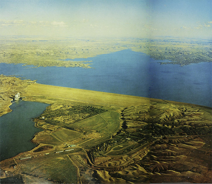
Behind the dam, the first of the "Missouri Great Lakes" filled with water.