Missouri River Recovery Program Logo

Connect with MRRP

MRRP Site Menu

Redirecting...

Announcements

Missouri River Recovery Program (MRRP)

What is it? 

The MRRP effort consists of two primary components:

  1. Identifying and implementing an action that will avoid a finding of jeopardy for three federally listed species: the piping plover, the interior least tern, and the pallid sturgeon. The current proposed action was described in the U.S. Army Corps of Engineers' October 2017 Biological Assessment. The proposed action allows the Corps to continue to operate for all authorized purposes while complying with all applicable laws, regulations, and treaty and trust responsibilities.  
  2. Implementing the Bank Stabilization and Navigation Project Fish and Wildlife Mitigation Project (BSNP Mitigation Project) as authorized under Section 601 of the 1986 Water Resources Development Act (WRDA) and Section 334 of WRDA 1999 and amended by Section 3176 of WRDA 2007.  For more information on these authorizations, go to the BSNP Mitigation Project page. It is recognized that some of the actions necessary to avoid jeopardy may contribute to the objectives of the BSNP Mitigation Project.  

What is a Biological Opinion?

Under Section 7 of the Endangered Species Act, the Corps is required to consult with the U.S. Fish and Wildlife Service (USFWS) to determine the potential effect of a proposed action on threatened or endangered species.  These consultations can result in a biological opinion issued by the USFWS.

Consultation with the USFWS on MRRP's proposed action concluded in April 2018. The resulting Biological Opinion found the proposed action will not jeopardize the existence of the pallid sturgeon, piping plover, or the interior least tern and will not destroy or adversely modify designated critical habitat for the piping plover.  

The Species and the River

The ecosystem of the Missouri River provides habitat for a wide variety of wildlife, including three federally listed threatened or endangered species. The endangered least tern and the threatened piping plover are shorebirds that use nonvegetated sandbars and reservoir beaches for springtime nesting. The river currently does not naturally build enough of the habitat these birds need to nest and feed. The endangered pallid sturgeon is an ancient fish species that lives in large rivers. Loss of habitat and changes to the river's natural flows may be contributing to the pallid sturgeon's decline.
Collapse All Expand All
 Interior Least Tern and Piping Plover

The least tern and piping plover are shore birds that nest along the banks of, and on sandbars in, the Missouri River. Changes to the river have led to less habitat for the birds. At times, predation and human disturbance of bird nests have also contributed to reduced bird success. The interior least tern was listed as endangered in 1985, and the piping plover was listed as threatened in 1986.

Every May through August, the Corps monitors the number of adults, nests, and fledglings produced on the river and reservoir reaches. Please go to the Science page for a list of the Corps' management actions for the least terns and piping plovers.  

Least tern photo   Interior Least Tern

For information on the Interior Least Tern, please follow this link to the U.S. Fish and Wildlife Service Website:  https://www.fws.gov/midwest/Endangered/birds/leasttern/index.html.

Thanks in part to successful recovery efforts, the U.S. Fish and Wildlife Service is considering delisting the interior least tern.    

Piping plover photo   Piping Plover

 For information on the Piping Plover, please see the below links to the U.S. Fish and Wildlife Service Website:

 Pallid Sturgeon  

Pallid sturgeon numbers began declining over 100 years ago, and it was listed as an endangered species in 1990. Engineered changes to the river have changed habitat and the fish community. Understanding which factors are suppressing pallid sturgeon numbers and what actions can be taken to benefit pallid sturgeon is a current focus of management efforts on the Missouri River. The Corps funds federal and state partner agencies to raise pallid sturgeon in fish hatcheries and stock them into the Missouri River as one way to begin to improve sturgeon numbers. The Corps and partner agencies also monitor the fish’s numbers along the river, including looking for naturally-produced pallid sturgeon.      

Pallid stugeon photo   Pallid Sturgeon

For information on the Pallid Sturgeon, please see the below links to the U.S. Fish and Wildlife Service Website:

Please see the Science page for information on Pallid Sturgeon Hatchery Support.


 The Missouri River

The Missouri River, the nation's longest, travels over 2,300 miles from Three Forks, Mont., to join the Mississippi River near St. Louis, Mo.

River History

For centuries, the river has served as the center of life for the inhabitants of North America's Great Plains. Following exploration and mapping by Lewis and Clark's Corps of Discovery in the early 1800s, the Missouri River became the gateway to the west.

Historically, the dynamic and untamed Missouri River has produced violent floods in the spring and summer with erosive forces that ate away its banks and turned its waters the color of mud.

Since Lewis and Clark returned from their expedition, the Army Engineers have had very close ties to the Missouri River. Over the years, the U.S. Army Corps of Engineers has been charged by Congress to remove snags, protect banks, construct navigation channels and build flood risk management structures (levees and dams) on the Missouri River to provide social and economic benefits to the nation. Some of these development activities on the Missouri River have come at the expense of the river's native fish and wildlife.

The River Today

Today, the Missouri River hosts a wide variety of interests and uses, all of which are considered in the river's recovery program. They include the authorized purposes of the Missouri River Main stem Reservoir system of fish and wildlife, flood control, hydropower, irrigation, navigation, recreation, water supply and water quality. Other important considerations include Tribal interests, cultural resources, and ecosystem services.

These uses have resulted in significant impacts to the Missouri River ecosystem:

  • Three million acres of natural river habitat altered
  • 51 of 67 native fish species now rare, uncommon or decreasing
  • Reproduction of cottonwoods, historically the dominant floodplain tree, largely has ceased
  • Aquatic insects, a key link in the food chain, reduced by 70 percent
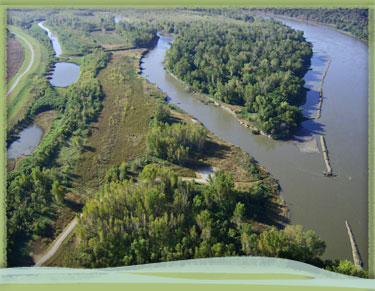
Photo of the Missouri River at Deroin Bend

News

Missouri River Recovery Implementation Committee to hold fall plenary session in Sioux Falls, South Dakota
9/6/2024
The U.S. Army Corps of Engineers, Omaha District, announced that the Missouri River Recovery Implementation Committee (MRRIC) will hold a plenary session Sep. 17-19, 2024, in Sioux Falls, South...
Monitoring of pallid sturgeon response to test flow continues with some surprising news
8/5/2024
The 2024 test flow from Fort Peck Dam was the first in a series of test flows intended to comply with the 2018 Biological Opinion. The test flow began April 26 with an initial flow peak in early May...
Notice of Solicitation of Applications for Stakeholder Representative Members for the Missouri River Recovery Implementation Committee
5/28/2024
The Missouri River Recovery Implementation Committee is soliciting applications to fill vacant stakeholder representative member positions. Members are sought to fill vacancies on the committee to...
Col. Robert Newbauer: U.S. Army Corps of Engineers to begin Fort Peck Flow Test
4/12/2024 UPDATED
The U.S. Army Corps of Engineers will conduct a flow test at Fort Peck starting no sooner than April 26, 2024, with a scheduled completion date of no later than September 1, 2024...
Public comment sought for proposed improvements around River’s Edge North in Council Bluffs, Iowa
12/20/2023
OMAHA, Neb. - The U.S. Army Corps of Engineers, Omaha District is soliciting comments regarding proposed improvements in River’s Edge North near L-627 Missouri River Left Bank Federal levee Flood Risk...